| |
 |
| |
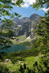
Morskie Oko
(photo: S. Pytel)
|
situated at 1395 meters asl, with its 700 000 visitors a year is the most frequently visited natural monument in Poland.
Morskie Oko is a postglacial lake with the area of 34.93 ha, approx. 862 m long and 566 m wide. It holds approx. 1 million m3 of crystal clear water. Substantial water transparency makes it possible to see the bottom at substantial depths. Close to shores the bottom is covered with rocks while closer to the middle it’s covered with gravel, sand and silt.
Water from the lake outflows in the Rybi Potok (the Fish Stream).
In the past, it was called Rybie Jezioro or Rybi Staw (Fish Lake or Fish Pond) due to its natural stock of fish as the lake is inhabited by trout.
The lake is closed in a glacial gully created by two glaciers, flowing from the cirques of Czarny Staw (Black Pond) and Dolina Za Mnichem (Valley Behind Monk). On the north, Morskie Oko is closed by the 20 meter-high moraine.
Situated at the bottom of the postglacial pothole, Morskie Oko is surrounded by soaring peaks – from the east towards west: Siedem Granatow (Seven Grenades) – the final section of Zabia Gran (Frog Ridge), Zabi Szczyt Nizni (Lower Frog Peak – 2098 m), Zabi Mnich (Frog Monk – 2146 m), Zabia Lalka (Frog Doll – 2095 m), Niznie Rysy (Lower Rysy – 2430 m), Rysy (2499 m), Zabi Kon (Frog Horse – 2291 m), Zabia Turnia Mieguszowiecka (Mieguszowiecka Frog Crag – 2336 m), Wolowy Grzbiet (Ox Ridge), Kazalnica Mieguszowiecka (Mieguszowiecka Pulpit – 2159 m), Mieguszowiecki Szczyt Czarny (Mieguszowiecki Black Peak – 2410 m), Mieguszowiecki Szczyt Posredni (Mieguszowiecki Intermediate Peak – 2393 m), Mieguszowiecki Szczyt Wielki (Mieguszowiecki Great Peak – 2438 m), Cubryna (Mop – 2376 m), Mnich (Monk – 2070 m), Szpiglasowy Wierch (Szpiglasowy Peak – 2172 m), Miedziane (Copper Peak – 2233 m), Opalony Wierch (Burnt Peak – 2115 m).
Everyone is attracted by the view of Mieguszowieckie Szczyty (Mieguszowieckie Summits), which rise 1.000 meters above the surface of the lake and enormous scree field at their foot as well as the soaring peak of Mnich (Monk – 2070 m).
Trails from Morskie Oko:
- red – to Rysy. Estimated time approx. 4 hours (in one direction)
- red – around Morskie Oko – estimated time approx. 1 hour
- blue – via Swistowka to Dolina Pieciu Stawow Polskich – estimated time approx. 2 hours
- yellow – via Szpiglasowa Przelecz to Dolina Pieciu Stawow Polskich – estimated time approx. 4 hours
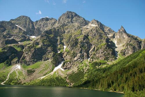 |
Morskie Oko, Mięguszowieckie Szczyty i Mnich
(photo: S. Pytel)
|
|


)
)


)
)