|
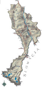
Bukowina Tatrzanska Commune lies on lands of two regions divided by The Bialka, a rapid clean river flowing from the heart of The Tatra Mountains with Podhale region on its left bank and Spisz region on the right. Their different histories and cultures and their mutual interaction at the same time compose the unique “frontier atmosphere”, which is noticeable at first sight.
The Commune consists of 8 villages: Bukowina Tatrzanska which stretches on the ridges and sides of Gliczarowskie Foothills (Pogorze Gliczarowskie), Gron and Lesnica which lie in its valleys, and Brzegi which is the farthest to the south. In The Bialka River valley, on its left bank lies Bialka Tatrzanska, and on the opposite bank - Czarna Gora, Jurgow and Rzepiska belonging to Spisz region.
 LOCATION LOCATION
Province of Malopolska
Tatra County
Area: 132,05 km2
Slovakian border crossings:
Lysa Polana, Jurgow
Population: 12 260
Zip code: 34-530
Commune Office (Urzad Gminy): ul. Dluga 144
Tel.: 018 20 770 10, 018 20 772 02
fax 018 20 008 79
TRANSPORT
National road No. 49
Provincial road No. 960, to border crossing at Lysa Polana
Provincial road No. 966, from Poronin
Zakopane railway station - distance 15 km
Nowy Targ railway station - distance 8 km
International airport – Krakow Balice – distance 120 km
CLIMATE
Mountain
Average temperature in July: + 15.3 °C
Average temperature in January: - 5° C
Snow cover in the Tatras: from October till May
in towns and villages: from November till April
|


)
)