| |
 |
| |
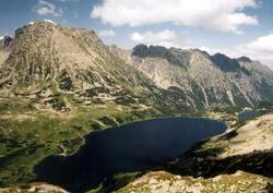
Dolina Pięciu Stawów Polskich
(photo: Paweł Murzyn)
|
It’s a branch of Dolina Bialki (Bialka Valley), upper level of Dolina Roztoki (Roztoki Valley) separated by Sciana Stawiarska – a high rock wall.
It’s an alpine postglacial valley with the area of 6.5 km2, 4 km long at the height of 1625 to 1900 m asl. In the valley, a glacier grooved a spacious bottom in the shape of a sickle with its ends pointing at north-west and south-east.
Total area of the lakes in the valley amounts to 61 ha, and they are:
- Wielki Staw Polski (Great Polish Pond) – situated at 1665 m asl. with the area of 34.14 ha and depth of 79.3 m. It is situated between the massifs of Miedziane (Copper Peak) and Kozi Wierch (Goat Peak), in the hole at the bottom of the glacial cirque. It outflows to Roztoka Stream.
- Zadni Staw Polski (Back Polish Pond)
- Czarny Staw Polski (Black Polish Pond) – situated at 1772 m asl. with the area of 13 ha and maximum depth of 50 m. It is situated in the upper part of the Valley, below the walls of Liptowskie Granie (Liptowskie Ridges).
- Mały Staw Polski (Small Polish Pond)
- Przedni Staw Polski (Front Polish Pond)
- Wole Oko (Bull’s Eye) – as this is a periodic pond, much lower than others – the name of the valley includes only five ponds.
At Przedni Staw Polski, at 1671 m asl., there is the highest hostel in the Polish Tatras - PTTK (Polish Tourist Country Lovers' Society) hostel named after Leopold Swierz.
The valley is surrounded by high peaks and ridges:
- the main ridge of the Tatras from Mount Swinica (2301 m asl.), through Walentkowa Gran (Walentkowa Ridge – 2156 m asl.) to Gladki Wierch (Smooth Peak – 2065 m asl.)
- Liptowskie Mury (Liptowskie Walls) to Szpiglasowy Wierch (Szpiglasowy Peak – 2172 m asl.) and further through the ridge of Miedziane (Copper Peak – 2233 m asl.) to Opalony Wierch (Burnt Peak – 2115 m asl.), where it borders on Dolina Rybiego Potoku (Fish Stream Valley).
- From Opalony Wierch there is a side branch with Swistowa Czuba (1764 m asl.) and Sciana Stawiarska (Stawiarska Wall) with the Siklawa Waterfall.
- The ridge of Orla Perc (Eagle’s Path) – from Krzyzne Pass (2112 m asl.) to Skrajny Granat (Side Grenade Peak 2225 m asl.) and further through Zawrat Pass (2159 m asl.) to Mount Swinica (2301 m asl.).
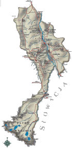
Trails in the area of Dolina Pieciu Stawow Polskich (Valley of Five Polish Ponds):
- green – along Dolina Roztoki to Wielki Staw Polski – estimated time approx. 2.5 hours
- black – branch of green trail to the hostel at Przedni Staw – estimated time from leaving green trail approx. 1.45 hours
- blue – from Morskie Oko to the hostel at Przedni Staw – estimated time approx. 2 hours – further to Zawrat Pass – estimated time approx. 2 hours
- yellow – from Morskie Oko via Szpiglasowa Przelecz to Dolina Pieciu Stawow – estimated time approx. 3.5 hours and further to Kozia Przelecz (Goat Pass) – estimated time approx. 1.5 hours
- black – from Wielki Staw to Kozi Wierch (Goat Peak) – estimated time approx. 2 hours
- yellow – from Wielki Staw to Przelecz Krzyzne – estimated time approx. 2 hours
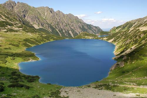 |
Dolina Pięciu Stawów Polskich
(photo: S. Pytel)
|
|


)
)


)
)